
Company and place search
Users can search companies, services, restaurants, blocks and points of interest inside Perini Business Park.
Case studies
Georeferenced digital map to guide visitors, employees and vehicles across a large business and industrial park | Joinville/SC
At Perini Business Park, Blucom implemented Blumaps to make navigation easier inside a large environment with internal roads, companies, industries, restaurants, commercial spaces and logistics areas. The solution helps different user profiles find destinations, generate routes and move more confidently across the park.
Case summary
Perini Business Park is a large environment with multiple internal roads, companies, industrial areas, logistics spaces, restaurants, services and commercial offices. In a site of this scale, guiding visitors and service providers is an important part of the experience and operation.
People arriving at the park can have very different profiles: a truck driver unloading at a company, a courier making a delivery, a visitor looking for a commercial office, an employee on the first day of work or a service provider who needs to quickly find the correct destination.
To support this journey, Blucom implemented Blumaps as a georeferenced digital map, accessible by mobile phone and prepared to guide internal movement in a more intuitive way.
The challenge was to make it easier to reach the correct destination inside Perini Business Park, considering that each user may have a different travel need. A pedestrian, a car and a truck do not necessarily follow the same paths, access points or travel times.
Many users also arrive without knowing the internal structure of the park. This makes it important to offer a simple search, location and route tool that can reduce questions at the entrance gate and make movement more predictable.
Blucom implemented Blumaps to turn the Perini Business Park map into an interactive digital experience. The application allows users to search places, view company and service information, generate internal routes and use mobile location to guide movement.
When the user is inside the park and allows location access, the map can use the phone GPS to show the current position and calculate the route from there. When the person is still away from Perini Business Park, the experience can integrate with Google Maps to support external travel to the site and then guide the internal path.
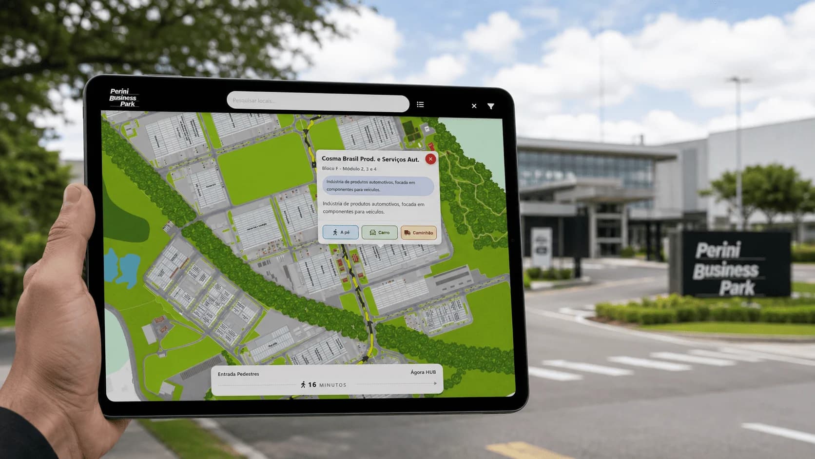
The journey starts when the user opens the map on a mobile phone, whether by QR Code at the entrance gate, the Perini Business Park website or another shared link. From there, the user can search for the desired place and choose the most suitable travel type.
A visitor can select a walking route. A driver can choose a car route. A truck driver can use the truck option, considering differences in access and internal circulation. This separation makes the experience more appropriate for each user profile and helps avoid generic guidance that does not fit every travel type.
When geolocation is enabled, the route can start from the real user position. This makes the map more useful for someone already inside the park who needs guidance among roads, blocks, companies and service areas.
Blumaps applied at Perini Business Park does not work only as an image of the site. It creates a digital layer for guidance, search and routing over the physical environment, considering the complexity of a business and industrial park.
The same concept can be applied to other large environments or sites with complex internal navigation, where visitors, vehicles, teams and service providers need to find destinations clearly.
Geolocation is used to improve the routing experience when the user allows location access on the phone. This feature helps the map show the current position and calculate the path from there, making navigation more practical inside the park.
Applied solution
The case combines search, routes, location and access channels to guide different user profiles in the same environment.
Users can search companies, services, restaurants, blocks and points of interest inside Perini Business Park.
With user permission, the map uses mobile location to show where the person is and start the route from the current position.
The application offers different routes for pedestrians, cars and trucks, respecting circulation characteristics, access points and travel times.
When the user is outside the park, the solution can support the external route to Perini Business Park and then continue with internal guidance.
At the entrance gate, visitors and service providers can access the map on a mobile phone by scanning a QR Code.
Each point can contain useful information, category, location and route actions to make it easier to reach the correct destination.
Results
People who do not know the site can search destinations and follow routes directly on a mobile phone.
Truck drivers, couriers and service providers can receive guidance that better fits the type of access and movement.
The digital map helps reduce recurring questions at the entrance gate and service points.
Companies, services, restaurants and blocks are organized in a visual and searchable experience.
Routes by travel profile make guidance more coherent for pedestrians, cars and trucks.
The map can evolve as the park changes, new companies arrive or new areas need visibility.
Products

Indoor digital map to guide visitors in large spaces
Routes, points of interest, QR Codes, kiosks, multilingual support, contextual information, and usage data for airports, shopping malls, events, and complex environments.
Use these pages to understand the product, industry and solution context behind the application.
Blucom develops digital maps and navigation solutions for complex environments, helping companies turn physical spaces into more accessible, searchable and location-oriented experiences.